
|
|
|
 The Indian Ocean is
unique in that it is limited in the north by the Asian
continent.One consequence of this geography (from Tomczak and Godfrey, 1994) is
that the Arabian Sea is forced by intense, anually reversing
monsoon winds. These strong winds force the ocean locally, and
they excite propagating signals (Kelvin and Rossby waves) that
travel large distances and affect the ocean remotely.
The Indian Ocean is
unique in that it is limited in the north by the Asian
continent.One consequence of this geography (from Tomczak and Godfrey, 1994) is
that the Arabian Sea is forced by intense, anually reversing
monsoon winds. These strong winds force the ocean locally, and
they excite propagating signals (Kelvin and Rossby waves) that
travel large distances and affect the ocean remotely.
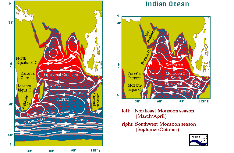 Thus, with such
extraordinary phenomena as the Somali current, the equatorial jets and others
(from Tomczak and Godfrey, 1994) which will be described, the
Indian Ocean is an ideal " laboratory " for
oceanographers, involving coastal, equatorial and subtropical
ocean circulations, and the interactions between them.
Thus, with such
extraordinary phenomena as the Somali current, the equatorial jets and others
(from Tomczak and Godfrey, 1994) which will be described, the
Indian Ocean is an ideal " laboratory " for
oceanographers, involving coastal, equatorial and subtropical
ocean circulations, and the interactions between them.
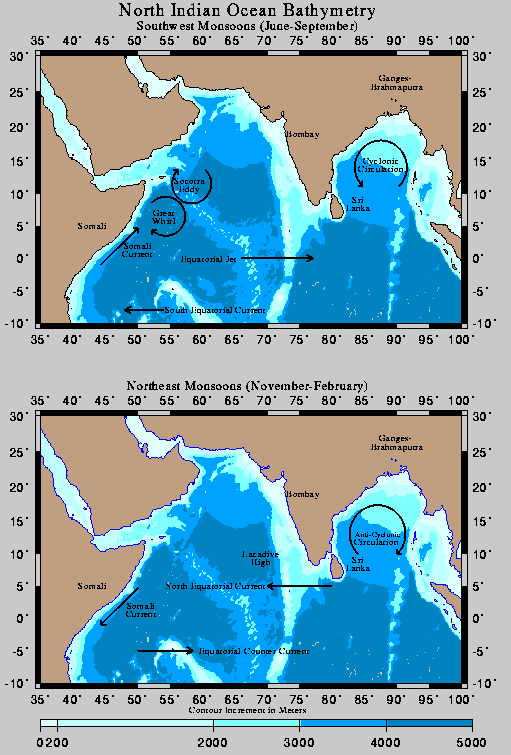
The influence of the monsoons on the Indian Ocean is seen in the reversal of the surface circulation and in the hydrographical conditions of the surface waters down to 10-20°S. The most striking effect of the monsoon winds is the reversal of the Somali Current (SC). This reversal is unique among the western boundary currents and has been a subject of great scientific interest since the mid-1960s, early 70s (Düing and Szekielda, 1971 ; Leetmaa, 1972, 1973 ; Bruce, 1973, 1978, 1979, 1983 ; Düing and Schott, 1978 ; Evans and Brown, 1981 ; Quadfasel and Schott, 1982, 1983 ; Swallow and Fieux, 1982 ; Shetye et al., 1994, Subrahmanyam et al., 1995).
| I.1.1. The Somali Current | links to the Somali Current |
(i) Current Measurements
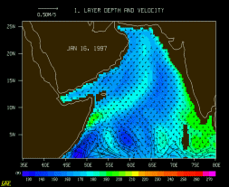
Southward flow in the SC during the Northeast Monsoon is limited to the region south of 10°N. It first occurs in early December near the equator and expands rapidly north in January with velocities of 0.7-1.0 m.s-1. The surface flow reverses in April, during the inter-monsoon period. During the Southwest Monsoon, the SC develops into an intense jet with extreme velocities of 2.0 m.s-1 for mid-May and 3.5 m.s-1 and more for June, observed during the Indian Ocean Experiment (INDEX, 1976-1979).
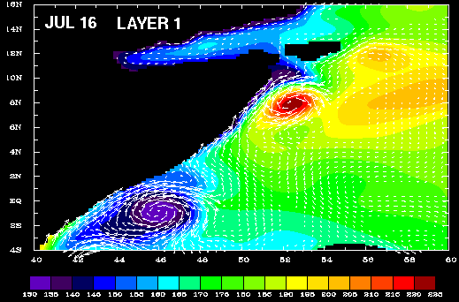
Measurements made in 1964 during the International Indian Ocean Expedition (IIOE, 1962-1965) and during the seventies show that the flow pattern of the SC is far more complicated than the continuous northward or southward flow as seen in climatological atlases (e.g. Schott, 1983). In particular, during the southwest monsoon, studies pertaining to this region indicate the presence of a two-gyre system - the Great Whirl between 5°n and 10°N with clockwise rotation, and a secondary eddy towards its south.
(ii) The Great Whirl and the two-eddies system
 The Great Whirl is
present in Ekman pumping calculation but not its neighbour eddy
in the south (Le Blanc, 1996). A
similar discrepancy is encountered by Luther
and O'Brien (1985) in their wind-driven numerical
shallow-water model which is " unable to reproduce the
strong upwelling wedge between the two gyres, as there are no
thermodynamics effects and no exchange of water between the upper
and lower layers [of the model, ...] ". Eventhough the
two eddies are present in their results, " the model
cannot reproduce the surface density fronts that [Swallow et al. (1983)]
observed " (see animation for the year 1997, in
particular the two eddies during september by Mark E. Luther, Zaihua Ji, and Haihua Liu -
University of South Florida Department of Marine Science).
The Great Whirl is
present in Ekman pumping calculation but not its neighbour eddy
in the south (Le Blanc, 1996). A
similar discrepancy is encountered by Luther
and O'Brien (1985) in their wind-driven numerical
shallow-water model which is " unable to reproduce the
strong upwelling wedge between the two gyres, as there are no
thermodynamics effects and no exchange of water between the upper
and lower layers [of the model, ...] ". Eventhough the
two eddies are present in their results, " the model
cannot reproduce the surface density fronts that [Swallow et al. (1983)]
observed " (see animation for the year 1997, in
particular the two eddies during september by Mark E. Luther, Zaihua Ji, and Haihua Liu -
University of South Florida Department of Marine Science).
Thus, " the development of the northward flow can be divided into two phases of different dynamics " (Tomczak and Godfrey, 1994). In May during the first phase, the second transition or inter-monsoon period, the SC is first established as a response to the wind reversal along the African coast, as well as to remote westerly winds just north of the equator. Lighthill (1969) concluded that a wind stress located 500 km away from the coast could generate a western boundary flux within a month, if baroclinic modes were taken into account. This result is also observed in data collected during the Monsoon Experiment (MONEX, 1979) (Luyten, 1982), as well as in numerical tests with a non-linear shallow-water model forced by a single equatorial Kelvin wave off the African coast (personal result).
This two-gyre system is stable until August or September, when the Southern Gyre propagates northward and merges with the Great Whirl, as was observed by Bruce (1973). Northward migration of the cyclonic and anticyclonic eddies north of the equator is an important feature of the Somali Current. Lin and Hurlburt (1981) and Luther et al. (1985), demonstrated that a simple reduced gravity model was able to produce this coalescence of the Great Whirl and the Southern Gyre during the late stage of summer monsoon.
(iii) Modeling the Somali Current
Several authors have been successful in modeling some aspects of the response of the SC to the southwest monsoon (Hulburt and Thompson, 1976 ; Cox, 1979 ; Luther and O'Brien, 1985, Simmons et al., 1985 ; Jensen, 1991; Mc Creary et al., 1993). The aim of those studies is to reproduce and understand the dynamics involved in the generation of the two-eddies pattern, associated with the undercurrent along the Somali coast. The precise role of thermodynamics and the different local and remote wind forcings are not fully understood.
 An important result to
bear in mind is the conclusion by Jensen (1991) (see figure from Tommy Jensen's
homepage) who suggests that baroclinic instability is partly
responsible for the decay of the Great Whirl. This process seems
to be triggered by seasonal Rossby waves which originate from the
west coast of India. Further tests showed that the formation of
cyclonic eddies associated with the weakening of the Great Whirl
is not caused by a decrease in local wind forcing, but rather by
redistribution of energy within the flow.
An important result to
bear in mind is the conclusion by Jensen (1991) (see figure from Tommy Jensen's
homepage) who suggests that baroclinic instability is partly
responsible for the decay of the Great Whirl. This process seems
to be triggered by seasonal Rossby waves which originate from the
west coast of India. Further tests showed that the formation of
cyclonic eddies associated with the weakening of the Great Whirl
is not caused by a decrease in local wind forcing, but rather by
redistribution of energy within the flow.
Finally, Jensen concludes that " the most important physical process is that vertical transfer of energy is possible, allowing baroclinic instability ". During the transition from summer to winter monsoon, his results suggest that several mechanisms play a role. These are advection through eddy-eddy interaction, eddy-wave interaction, and downward energy propagation, indicating that baroclinic instability and remote forcing by planetary waves are important parts. These results are important to remember when dealing with equatorially trapped waves which will be discussed in a following chapter.
| I.1.2. The Arabian Sea | links to the Arabian Sea |
(i) The Cooling of the Arabian Sea and Deep Recirculation
Due to upwelling of cool subsurface water in the Arabian Sea, there is an annual-mean heat flux into the northern ocean ; hence, there must be a meridional circulation cell that carries warm surface water out of, and cool subsurface water into the region (Mc Creary et al., 1993). Duing and Leetma (1980) in fact remark that the determination of this circulation cell should be a major goal of Indian Ocean research, a goal that has not yet been attained.
Annual mean heat flux into the Arabian Sea is associated with abrupte cooling, (i.e. decrease in heat content and surface temperature). This cooling occurs during the southwest monsoon in boreal summer, at a time which, in other parts of the Northern Hemisphere, would coincide with warming. The ocean circulation, characterized in boreal summer by strong coastal upwelling in the SC region and southeastward Ekman flow in the interior, must therefore play a major role in exporting heat out of the Arabian Sea during the southwest monsoon. The Indian Ocean is unique in that, because the mean wind stresses change from easterly to westerly across the equator, the annual Ekman transports are southward on both sides of the equator (Godfrey et al., 1995). However, Ekman transport, having a lesser amplitude during the northeast monsoon than during the southwest monsoon, especially south of 10°N, its change of sign is not sufficient to explain why the heat transport south of the Arabian Sea keeps a similar amplitude when reversing from August to its February value. Deeper changes in the circulation must thus occur and these seasonal changes in deeper layers may reasonably occur along the western boundary (Wacongne and Pacanowski, 1996).
| I.1.3. The Bay of Bengal | links to the Bay of Bengal |
 The Indian subcontinent
divides the north Indian Ocean into two basins, the Arabian Sea
described above and the Bay of Bengal which is smaller. A unique
feature of the Bay are a western boundary coastal upwelling (when
most of the classic coastal upwelling regions of the world's
oceans occur along eastern boundaries of the ocean basins). It is
also worth noting the large freshwater influx it receives,
especially during the southwest monsoon (the rainy season). It is
also known for the cyclones it breeds.
The Indian subcontinent
divides the north Indian Ocean into two basins, the Arabian Sea
described above and the Bay of Bengal which is smaller. A unique
feature of the Bay are a western boundary coastal upwelling (when
most of the classic coastal upwelling regions of the world's
oceans occur along eastern boundaries of the ocean basins). It is
also worth noting the large freshwater influx it receives,
especially during the southwest monsoon (the rainy season). It is
also known for the cyclones it breeds.
Data in the Bay of Bengal are somewhat limited. Observations show that monsoons in the western Indian Ocean are much stronger than the monsoons in the Bay of Bengal (Tsai et al., 1989). Legeckis (1987) demonstrated the appearance of a western boundary current in the Bay of Bengal, using SST data obtained from adavanced very high resolution radiometer (AVHRR) carried on board the NOAA 9 satellite. Some local studies used in situ-measurements along the eastern coast of India, in order to describe this western boundary current of the seasonal subtropical gyre in the Bay of Bengal (Shetye et al., 1991, 1993, 1996).
Because of the scarcity of measured data in this region, Potemra et al. (1991) used a wind-driven model to simulate ocean currents in the region of the Bay of Bengal. The model used for their study was developped at the Florida State University (FSU) and is the same used by Jensen (1991) to study the Somali Undercurrent mentioned above. It is a reduced gravity, three and a half-layer model. Modeling of the East India coastal current has also been investigated by McCreary and Han (1996) with a linear, continuously stratified model, forced by Hellerman and Rosenstein (1983) winds. Results are summarized in the following paragraphs.
(i) the Western Boundary Current or East Indian Current
Like the Somali Current in the Arabian Sea, the East India Coastal Current (EICC) reverses direction twice a year, flowing northeastward from February until September with a strong peak in March-April and southeastward from October to January with strongest flow in November.
The circulation in the Bay of Bengal is characterized by anticyclonic flow during most months and strong cyclonic flow during November. A remarkable feature which still requires an explanation is the fact that the northward East Indian Current - seemingly an extension of the North Equatorial Current during the Northeast monsoon - persists during May with velocities reaching 0.7-1.0 m.s-1 , when flow south of the Bay turns eastward to form the inter-monsoon jet (see section I.3.1.) (Tomczak and Godfrey, 1994). During the Southwest monsoon season, currents in the entire bay are weak. Complete reversal of the East Indian Current into the East Indian Winter Jet is not achieved until late October, when water from the Equatorial Jet enters the Bay in the east and a cyclonic circulation is established. The East Indian Winter Jet is a powerful western boundary current with velocities consistently above 1.0 m.s-1 . It follows the topography south of Sri Lanka and feeds its water into the Arabian Sea (Tomczack and Godfrey, 1994).
McCreary et al. (1993) used a two and a half-layer, thermodynamic, numerical model, to test the forcing in the Bay of Bengal. They made a main run with wind forcing and a run without wind in the Bay of Bengal only. In March, they find that current along the east coast of India has the same southward direction that it had in January, whereas in the main run it reverses to flow strongly northward. It follows that the reversal must arise from forcing within the Bay. One possible cause is the presence of upwelling-favorable winds elsewhere in the Bay, namely on the northeast boundary of the Bay throughout the Northeast Monsoon and along the northwest boundary beginning of March. A second possibility is forcing by negative wind curl in the interior of the western Bay. This explains why the East Indian Current does not reverse at the same time as the North Equatorial Current as mentioned by Tomczack and Godfrey (1994).
However, Shetye et al. (1991, 1993) based their study of the Western Boundary Current on hydrographic data and on climatology of ship-drifts and conclude that the Bay is driven mainly locally by wind stress curl but the role of local driving, vis-a vis the role of remote driving proposed by Potemra et al. (1991) and McCreary et al. (1993) requires further observation. This conclusion was confirmed by Shankar et al. (1996) who analyzed the dynamics of the East India Coastal Current forced by Ekman pumping within the Bay as well as local alongshore winds. The role of freshwater plumes from the Ganges and Brahmaputra rivers is not yet fully understood. It is possible that the plumes are the precursor to the northeastward coastal current which dominates the circulation of the region during September-January after the withdrawal of the southwest monsoon.
Another possible mechanism are coastal Kelvin waves propagating northward along the eastern boundary of the Bay excite westward propagating Rossby waves into the interior of the Bay. These northward-propagating Kelvin waves are excited by the reflection of equatorial Kelvin waves at the eastern boundary of the basin. Kelvin waves, which after travelling along the northern boundary of the Bay and on reaching the east coast of India in March generate a poleward current.
(ii) the Andaman Sea
In the Andaman Sea, east of the Bay of Bengal, the oceanic flow changes direction twice during the year. (Potemra et al., 1991). Model layer thickness reveals coastal Kelvin waves propagating along the coast, travelling the entire perimeter of the Adaman Sea and the Bay of Bengal. This wave excites westward propagating Rossby waves into the interior of the Bay. Similar results are found by McCreary et al. (1993). They find that even in the absence of wind forcing in the Bay of Bengal, deepening of the upper-layer in the eastern Bay is still present in July as in the main-run, demonstrating that this is remotely forced from the equator via the reflection of a downwelling-favorable equatorial Kelvin wave. Reflection of Rossby waves from the eastern boundary are also observed.