
|
|
|
I.2. The Indonesian Throughflow |
links to the Indonesian throughflow |
I.2.1. The Geography of the Indonesian Throughflow
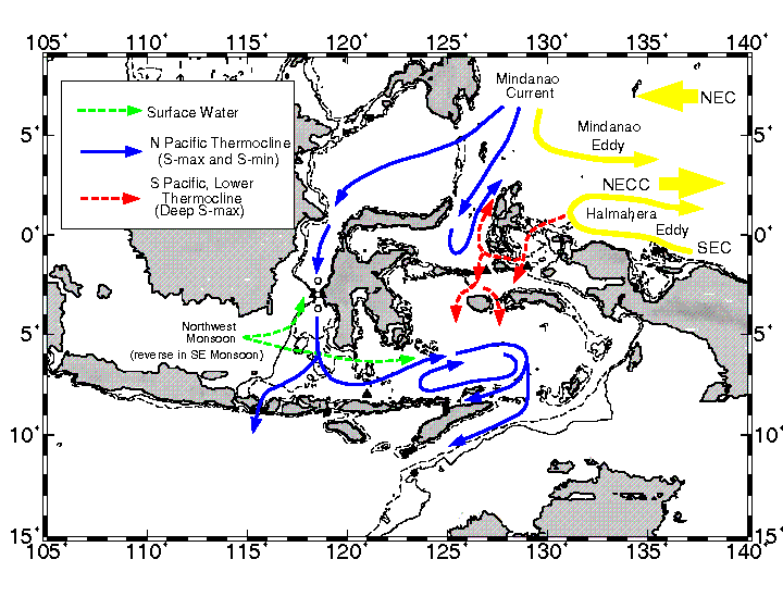 The Indonesian throughflow is a system
of surface currents (see figure from the ARLINDO Project of the
Lamont-Doherty Earth Observatory - Columbia University ) flowing
from the Pacific to the Indian Ocean through the Indonesian seas.
It is the only flow between ocean basins at low latitudes and,
consequently, plays an important role in the meridional transport
of heat in the climate system, all the more so since this
transport originates from the warm-pool of the Pacific and enters
into the colder waters of the South
Equatorial Current (SEC) of the Indian Ocean.
The Indonesian throughflow is a system
of surface currents (see figure from the ARLINDO Project of the
Lamont-Doherty Earth Observatory - Columbia University ) flowing
from the Pacific to the Indian Ocean through the Indonesian seas.
It is the only flow between ocean basins at low latitudes and,
consequently, plays an important role in the meridional transport
of heat in the climate system, all the more so since this
transport originates from the warm-pool of the Pacific and enters
into the colder waters of the South
Equatorial Current (SEC) of the Indian Ocean.
I.2.2. The Driving Force of the Indonesian Throughflow
This flow of water is governed by strong pressure gradient from the Pacific to the Indian Ocean. The annual and semiannual variations in transport are related dynamically to the monsoon winds. The annual signal has a maximum during the southeast monsoon in July and August and a minimum in January and February. This is because winds are blowing westward during the southwest monsoon in the tropical Indian Ocean and causes a lowering of sea level on its eastern side (and an increase on the western side). Reversely, during the northeast monsoon, winds reverse in the tropical Indian Ocean, leading to an increase of sea level on its eastern side, thus minimizing the transport. The western Pacific shows also annual variations but the sea level difference between the two basins is governed chiefly by the sea level in the eastern Indian Ocean (Wyrtki, 1987). Dynamic height computations determine the average sea level difference between Davao in the Philippines and Darwin in Australia as 16 cm. And show that most of the pressure gradient for the is contained in the upper 200 m.
I.2.3. Volume Transport Measurements
Measurements of the volume transport of throughflow has proven to be difficult due to the extremely complex coastline and topography of the Indonesian Seas, as well as the highly variable nature of currents in the throughflow region. The maximum net, relative transport toward the west between Australia and Indonesia is 12 Sverdrup (Sv = 106 m3.s-1) in August/September (Meyers, 1995) which is in agreement with the numerical model of Kindle et al. (1989). However, some other measurements and numerical model results find values around 16 Sv (Cox, 1975 ; Semtner and Cherwin, 1988 ; Godfrey, 1989, Schiller et al., 1996) with peaks during the southeast monsoon (August) atteining 19-20 Sv (Fieux et al., 1994 ; Molcard et al., 1994).
I.2.4. The Zonal Jet of the Throughflow
The effect of the throughflow on the Indian Ocean oceanic circulation have been investigated through the use of several numerical models show that the throughflow crosses the Indian Ocean as a rather well-defined zonal jet (Godfrey, 1981). Mc Creary et al. (1993) used a 21/2 layer thermodynamic numerical model to explore the influence of the Pacific-Indian throughflow by specifying a 10 Sv transport across the Indonesian boundary. (10 Sv is also the value estimated by Godfrey (1981) using the Sverdrup relation in the Indian Ocean expressed in terms of mass transport). The authors note that the differences in fields between the test with throughflow and the main runs without throughflow are remarkably similar to analogous difference fields in the global GCM solutions of Hirst and Godfrey, 1993.
 Nearly all of the throughflow moves directly
westward across the interior ocean, bends southward at the
African coast, and eventually leaves the basin in the Agulhas
Current. This is due to the fact that in the interior ocean the
influence of mixing is weak, and hence the interior currents are
necessarily zonal ; the mixing acts to broaden the zonal jet
to the west and to allow weak countercurrents on either side.
Nearly all of the throughflow moves directly
westward across the interior ocean, bends southward at the
African coast, and eventually leaves the basin in the Agulhas
Current. This is due to the fact that in the interior ocean the
influence of mixing is weak, and hence the interior currents are
necessarily zonal ; the mixing acts to broaden the zonal jet
to the west and to allow weak countercurrents on either side.
This is also found in a shallow-water model by simply letting a constant (in time and along the open throughflow boundary) zonal transport enter the Indian Ocean across the throughflow (personal results). The upper-layer shear flow circulates anticyclonically about the region of positive height anomaly. Studies also showed that the throughflow strengthens the cooling along the Australian coast and across the interior ocean in a band centered about 12°S. This cooling results from anomalous advection for the coastal regions along Australia, Indonesia and in the Agulhas Current, but is due to deepening of the mixed upper-layer in the interior ocean.
I.2.5. Kelvin and Rossby Waves generated by the throughflow
Because the throuflow adjusts to geostrophic balance and is confined to the upper layer (200 m, Wyrtki, 1987), steric height is increased across the inflow region, off West Australia. This increase spreads poleward along the Australian and Indonesian coast via Kelvin waves and westward into the ocean interior via Rossby waves. If several years pass by with no further changes in the throughflow transport and no changes in the wind field, the Rossby waves will cross the ocean in all latitudes and will then be reestablished throughout the ocean.
These results are compatible with the study of Périgaud and Delecluse (1992) who find through Geosat data and shallow-water simulations that " off-equatorial annual sea-level variations propagate westward and poleward at speed compatible with Rossby wave theory ". The authors find that " the best correlation between the simulations and the observations is along 15°S where it takes one year for the annual wave to cross the Indian Ocean from 100°E to 50°E. Eventhough their wind-driven numerical model has closed boundary conditions, one can assume that those waves are generated by the throughflow since the authors conclude that " if the initial upper layer is chosen thicker (300 m instead of 200 m), the wave speed is increased so that the best correspondance between Geosat and the model is further south. [...] This annual Rossby wave is not locally generated by the wind. Indeed the wind-stres curl does not present any propagation at all and the patches of increased wind-stress curl are not correlated in time with any sea-level changes. This annual signal corresponds rather to free Rossby waves radiating away from the eastern coast and this has been demonstrated with simulation tests (Périgaud et Delecluse, 1991). Differences between simulated and observed variations there results from the model assumptions (shape of the boundary) rather than from the orbit or the tropospheric error contribution in altimeter data. "
Propagating Rossby waves signal originating near the eastern boudary are also found in the analysis of Topex/Poseidon altimeter data in the latitude of 5°-20°S (Morrow and Birol, 1997). The authors mention that " these waves appear to be forced east of 100°E by the seasonnal cycle of the trade winds (Woodberry et al., 1989), although it is not well understood why the maximum amplitude then occurs where the wind-stress curl is weakest ". This result confirms that a possible origin for the Rossby waves are the fluctuations in the throughflow transport.
It is worth mentioning that the dynamics of the eastern boundary current along the western Australian coast, known as the Leeuwin Current, are very unusual. In the Pacific and Atlantic Oceans equatorward winds along the eastern boundary produce coastal upwelling, an equatorward surface flow, and a poleward undercurrent. In the Indian Ocean, annual mean winds along western Australia do blow towards the equator, but at the surface a vigorous poleward flow runs against the wind, and the undercurrent is equatorward. The reason is that eastern boundary currents are driven by the combined effects of longshore winds and longshore pressure gradients in the upper ocean. (Tomczak and Godfrey, 1994). Godfrey (1981) suggests that this anomalous behavior off West Australia is due to the volume transport from the Pacific to the Indian Ocean.
We will come back to the eastern boundary of the Indian Ocean when discussing the interannual variations.